CBSE Notes For Class 6 Geography Social Science Chapter 6 Our Country India
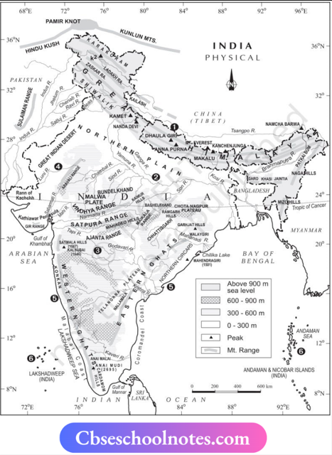
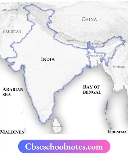
- India is a country with a large geographical expanse. It is surrounded by the lofty Himalayas in the North, the Arabian Sea in the West, the Bay of Bengal in the East, and the Indian Ocean in the South.
- India has an area of about 3.28 million sq. km. The North-South extent from Ladakh to Kanyakumari is about 3,200 km and the East-West extent from Arunachal Pradesh to Kuchchh is about 2,900 km.
- The high mountains, the Great Indian Desert, the Northern Plains, the uneven plateau surface, and the coasts and islands lead to a diversity of landforms in India. It has a great diversity in climate, vegetation, and wildlife as well as in the language and culture.
- According to the 2011 Census, India is the second most populated country in the world after China.
Locational Setting
- India is located in the Northern Hemisphere. The Tropic of Cancer (23°30’N) passes almost through the middle of the country.
- India extends between 8°4’N and 37°6’N latitudes from South to North and between 68°7’E and 97°25’E longitudes from West to East.
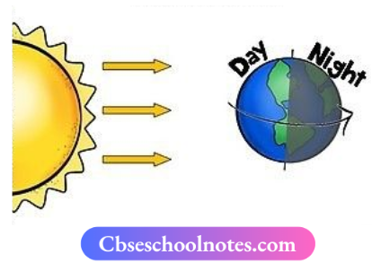
- As India has a great longitudinal extent of about 29°, there could be large differences in the local time of places located at two extreme points of India.
- As the local time changes by four minutes for every one degree of longitude, the difference between these two points would be of about two hours.
- The Sun rises two hours earlier in the East (Arunachal Pradesh) than in the West (Gujarat).
- To solve this problem, the local time of longitude of 82°30’E has been taken as the Indian Standard Time. This meridian or longitude is also termed the Standard Meridian of India.
CBSE Notes For Class 6 Geography Chapter 6 India’s Neighbours
- India shares its land boundary with seven countries. These are China, Bhutan, and Nepal to the North, Pakistan and Afghanistan to the West, and Bangladesh and Myanmar to the East.
- Sri Lanka and Maldives are the island neighbours of India which lie across the sea to the South. The Palk Strait separates Sri Lanka from India.
CBSE Notes For Class 6 Geography Chapter 6 Political and Administrative Divisions
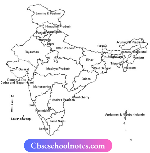
- India is divided into 28 states and 8 union Territories for administrative purposes. Delhi is the national capital.
- The states have been formed on the basis of languages.
CBSE Notes For Class 6 Geography Chapter 6 Physical Divisions
India has a variety of physical features such as mountains, plateaus, plains, coasts, and islands.
Himalayan Mountain: In India, the snowcapped Himalayas are standing as sentinel in the North of India. Him and Alaya mean the abode of snow.
- The Himalayan Mountains are divided into three main parallel ranges.
- The Northernmost is the Great Himalayas or Himadri. The world’s highest peaks are located in this range. Middle Himalaya or Himachal lies to the South of Himadri, having many popular hill stations. The Shivalik is the Southernmost range.
Northern Indian Plains: These lie to the South of the Himalayas and are generally level and flat. They are formed by the alluvial deposits laid down by the rivers Indus, the Ganga, the Brahmaputra, and their tributaries.
These river plains provide fertile land for cultivation thus, there is a high concentration of population in these plains.
Great Indian Desert: It is found in the Western part of India. It consists of a dry, hot, and sandy stretch of land with very little vegetation.
Peninsular Plateau: It is situated to the South of the Northern plains. It is triangular in shape and its relief is highly uneven. Thus, it has many hill ranges and valleys. It is rich in minerals like coal and iron ore.
- Aravalli hills, one of the oldest ranges of the world, border the plateau on the North-West side. The Vindhyas and the Satpuras are the important ranges in the Peninsular plateau.
- The rivers Narmada and Tapi flow through these ranges. These are West flowing rivers that flow into the Arabian Sea.
- The Western Ghats or Sahyadris border the plateau in the West and the Eastern Ghats border it in the East. The Western Ghats are almost continuous while the Eastern Ghats are broken and uneven.
Coastal Plains: Coastal plains lie to the West of Western Ghats and to the East of Eastern Ghats. The Western Coastal plains are very narrow, whereas the Eastern Coastal plains are much broader.
- There are a number of East east-flowing rivers. The rivers IT w Mahanadi, Godavari, Krishna, and Kaveri drain into the Bay of Bengal. These rivers have formed fertile deltas at their mouth For Example. Sundarbans delta.
Groups of Islands: Lakshadweep and the Andaman and Nicobar Islands are two groups of islands found in India. Lakshadweep Islands are located in the Arabian Sea. These are coral islands located off the coast of Kerala.
- The Andaman and Nicobar Islands lie to the southeast of the Indian mainland in the Bay of Bengal. These islands were affected by the Tsunami in 2004. A tsunami is a huge sea wave generated due to an earthquake on the sea floor.