
CBSE Class 8 Geography Chapter 5 Natural And Man- Made Disasters
A disaster is a natural or man-made event that causes large-scale loss of life and property.
- The impact of such events may differ at different times, depending on their magnitude as well as the nature of the environment they affect.
- A thing or a condition that might lead to a disaster is called a hazard. For example, an active volcano is a hazard for the people living close to it.
- When it erupts, it can turn into a disaster.
- Similarly, a chemical factory is a hazard for the people living around it, as an accidental leakage of poisonous gases can be disastrous.
- Most of the human settlements are at risk from one or the other hazard.
- The chances of these hazards turning into a disaster depend on the location of the place.

For example:
Towns located near a river or in earthquake-prone zones are at higher risk of disasters.
- Similarly, coastal areas are prone to tsunamis and cyclones, whereas hilly areas are prone to floods and landslides.
- With preparedness and certain precautionary measures, these hazards can be prevented from turning into a disaster.
- Disasters are classified into two types: Natural and Man-made.
CBSE Class 8 Geography Chapter 5 Natural Disasters
Natural disasters are of natural origin and caused by forces of nature. They are geological or weather-related occurrences, such as earthquakes, landslides, volcanic eruptions, fires, floods, cyclones, tsunamis, droughts, etc., that kill thousands of people and destroy habitats and property.
- A flood occurs when water flows above and beyond its normal level or course. When this water spreads out over a floodplain, it becomes a natural disaster.
- A floodplain is a long flat area of land along either side of a river made up of soil deposits carried by river water.
- Such a flood is also called a riverine flood. This is caused by rainwater or melting snow draining into the river faster than the river can discharge water into the sea.
- The amount of water, that a river can hold before a flood starts, is known as channel capacity.
Causes of Floods
The natural factors that cause floods are:
- Prolonged high-intensity rainfall.
- The blocking of the free flow of the rivers because of enormous debris provided by landslides and volcanic eruptions.
- Meandering courses of the rivers.
The man-made factors that cause floods are:
- Building activity and eventual urbanisation.
- Construction of bridges and reservoirs.
- Agricultural practices.
- Deforestation.
- Massive erosion along the river banks is causing large-scale land decay.
- Vanishing forest cover and open space.
Impact of Floods
Floods are one of the most destructive forms of natural disasters, causing huge losses of life and property.
For example:
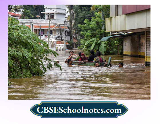
Floods in Kerala in August 2018 caused immeasurable misery and devastation.
- Hundreds of lives were lost. Thousands of homes were destroyed, and many more were damaged.
- The flooding affected hundreds of villages and destroyed thousands of kilometers of roads.
- According to the Kerala State Government, the total losses were estimated at around Rs. 40,000 crores.
- Flood waters inundate agricultural fields and destroy crops.
Floods cause contamination of drinking water Eind lead to water-borne diseases like jaundice and diarrhoea.
- In coastal Eireas, the sea water not only destroys life and property but also makes the soil saline and unfit for cultivation.
- Flooded areas get isolated from the rest of the country.
- Economically and socially backward communities are the worst affected and take longer to come back to the kind of life they were leading before the disaster.
Earthquakes
An earthquake is a sudden trembling or shaking of the Earth’s crust. It is caused by the movement of the lithospheric plates under the Earth’s surface. Volcanic eruptions also sometimes cause earthquakes.

- During an earthquake, the surface of the earth shifts, shakes and moves, which destroys buildings and other structures as well as natural habitats.
- Earthquakes begin deep below the ground. The point where the earthquake originates is called the focus or hypocentre of the quake.
- The point on the surface of the earth directly above the focus is known as the epicentre. Seismologists are scientists who study earthquakes.
- They use seismographs to record and measure the motion of the ground and the location where the earthquake takes place.
- The magnitude (energy released) of an earthquake is measured by Richter Scale and the intensity (effects) of an earthquake is measured by Mercalli Scale.
The Bureau of Indian Standards (BIS) has classified different regions in India into Zones II to V, taking into consideration earthquake records, tectonic activities and damage caused.
Zone II is considered the least seismically active, while Zone V is the most active. Zone IV and V fall under ‘severe’ to very severe’ categories, respectively, as shown in the map given on the next page.
- According to the National Centre for Seismology (NCS), 29 Indian cities and towns, including Delhi and the capitals of nine States, fall under ‘severe’ to Very severe’ seismic zones.
- A majority of these places are in the Himalayas, one of the most seismically active regions in the world.
- Delhi, Patna (Bihar), Srinagar (Jammu and Kashmir) Kohima (Nagaland), Shimla (Himachal Pradesh), Dehradun (Uttarakhand), Imphal (Manipur) and Chandigarh fall under severe seismic Zones.
Impact of Earthquakes
Since earthquakes are sudden and occur without any warning, they cause immense loss to life and property. Destruction of life and property results on account of the following:
- Construction of houses, roads, buildings, bridges and settlements in the seismic zones or areas prone to earthquakes. Building of dams on rivers around seismic zones.
- Weak and temporary houses are not strong enough to bear the shocks.
- On steep slopes, objects rolling and falling of objects hit the people and kill them.
- Earthquakes trigger landslides. A landslide is a sudden collapse of a large mass of hillside down a slope.
- When the landslides occur in the form of huge blocks, they are known as rock avalanches.

Landslide is a recurring feature on the hills. In the Himalayas, rapid denudation of forests and human activities have increased the frequency of landslides mainly during the rainy season.
- Sudden landslides can cause great destruction across a wide area of habitable land. Landslides can cause floods when their debris blocks river channels.
- Earthquakes under seas cause Tsunamis. A tsunami is a series of waves in the ocean caused by the displacement of ocean water by sudden earthquakes or rock movement under the sea. A tsunami waves can travel at 700 km per hour in deep seas.
A tsunami can strip coasts of sand, uproot trees and wipe out coastal towns. Travelling hundreds of metres inland, it can flood coastal towns.
- A tsunami triggered a wave of destruction across the Indian Ocean on December 26th, 2004.
- It was created by an undersea tectonic disturbance of 8.9 magnitude earthquake, just off the northern tip of Indonesia’s island of Sumatra.
- Thousands of people were killed by this massive tsunami. Thailand, Malaysia, Indonesia, Sri Lanka, Bangladesh, and India were badly affected. It is regarded as one of the most powerful earthquakes in history.
- The death toll rose to more than 1,50,000
Cyclones
Cyclones are violent storms that usually develop over the warm ocean waters. A low pressure gradually begins to form over the warm water bodies. Cool winds from surroundings high pressure areas rush in towards the low pressure. This causes the winds to blow towards the low pressure centre at a very high speed.
- These winds develop high speed and have a circular motion, and are very destructive.
- They are accompanied by torrential rains and storm surges and storm tides. A storm surge refers to the pushing of water onto the shore by a storm. It can be as rapid as several feet in just a few minutes.
- Even a one-foot deep storm surge at high tide, can cause abnormal rise in water level, reaching up to 20 feet or more in some cases.
- Adding to the destructive power of the rushing water is the large amount of floating debris that typically accompanies the surge.
- Trees, pieces of buildings and other debris float on top of the storm surge and cave in on anything that comes in its way.
The storm surge can begin to rise a day before the storm hits, cutting off escape routes when low-lying highways are flooded.
- The storm surge is the most dangerous part of a hurricane’s hazard. The high death tolls of the ten deadliest hurricane disasters in the USA, including Hurricane Katrina of 2005, were primarily due to the storm surge.
- By far the most devastating disasters in India are due to tropical cyclones. More tropical cyclones form in the Bay of Bengal than in the Arabian Sea, the highest frequency being in May, October and November.
- On average five to six such cyclones form in a year and nearly half of which develop into severe storms.
- The States which are prone to Cyclones in India include Andhra Pradesh, Gujarat, Odisha, Puducherry, Tamil Nadu and West Bengal.
- Cyclone Vardah, which hit the Tamil Nadu coast in December 2016, with a wind speed of 130 km per hour,r caused heavy rains and resulted in severe damage to buildings and properties, uprooted trees, and electric poles.
- It also caused power cuts for hours, overturned vehicles on the roads, and severely damaged banana plantations, papaya groves, rice paddies, and other food crops


Drought
Drought is defined as an acute shortage of water and crop failure that results when the average rainfall for an area drops far below the normal level for a long time.
- The severity of drought is determined by such factors as the decrease in moisture in an area and the soil, the duration of dry period and the size of the area affected.
- Droughts of brief duration generally do not have significant long lasting effects on organisms and the environment. However, lengthy droughts can have a serious impact.
Causes of Drought
Drought is attributed mainly to climatic and soil conditions, as well as an increasing human and livestock population.
- Prolonged dry spells due to the failure of rains.
- Low moisture retention capacity of the soil.
- The semi-arid or drylands have very high day temperatures during summer, which causes evaporation of soil moisture.
- The exploitation of groundwater, which is drained for domestic, agricultural, and industrial purposes.
- Insufficient or no recharging of the groundwater.
Impact of Drought
Drought leads to shortage of water for drinking and for normal domestic needs. It causes shortage of water for agricultural operations.
- It results in a shortage of food, fodder, and employment.
- It forces people to migrate to areas where water is available.
- During a drought, lakes and ponds dry up, aquatic organisms lose their habitat, and terrestrial organisms lose their water source.
- Severe drought results in a famine that causesthe death of a large number of people and animals in the area
CBSE Class 8 Geography Chapter 5 Man-Made Disasters
Man-made disasters are exclusively of human origin, involving man’s activities. They are caused due to an error, negligence, failure ofan equipment or deliberate acts like terrorist attacks.
Such disasters include explosions, wars, air crashes, sinking of boats, train accidents, collapse of bridges, dam failures, building fires, toxic wastes, etc. Terrorist act of blowing up a train or a building with explosives and nuclear attacks are also man-made disasters.
Fire in Buildings
The causes of fire hazards in buildings are:
- A fire in a domestic area originates near the kitchen where there is a mechanical failure of the cooking equipment.
- Room heaters and fireplaces are within the rooms.
- Poor electric wiring and the use of defective electrical appliances.
- Smoking sometimes may cause fire.
- The storage of hazardous chemicals or inflammable articles

Forest Fires
The four main causes of forest fires are:
1. Natural:
Fires caused by lightning or volcanic eruptions.
2. Accidental:
Fires caused by sparks from the wheels of trains or certain locomotives.
3. Negligence:
Fires are caused by cigarette stubs or matches along roadways, in rural areas, and along railway lines.
- Fires are caused by agricultural and forestry activities for the clearing of uncultivated land, for the clearing of plant residue, for the renewal of pastures, for the burning of stubble, and for the clearing of road and railway embankments.
- Fires caused by other forms of negligence originate from recreational and tourist activities — the lighting of firecrackers and rockets, blasting of landmines or explosives, the use of electric or mechanical devices, shooting exercises, and the burning of waste in illegal dumps.
4. Arson:
Fires are caused to destroy forestry operations or in connection with poaching or organised crime. Such fires cause great harm to wildlife by destroying their natural habitats.
Impact of Forest Fires
Forest fires destroy millions of hectares of vegetation and property.
- The smoke and smog produced during forest fires decrease the amount of sunlight and induce respiratory problems in wildlife.
- The forest fires affect food crops, transport, and tourism.
- Forest fires have an impact on insects and fruit trees, disrupting the food chain for predators and other species.
- Wildlife are more likely to come into conflict with human populations when they flee burning forests or are forced out to look for a new habitat or food sources.
- Large fire events can also create acid rain conditions, further damaging forest habitat. Forest fires release large amounts of greenhouse gases into the atmosphere and cause global warming and climate change.
- Industrial and Nuclear Accidents Industrial accidents occur due to dangerous procedures, infrastructure failures, explosions, pollution caused by the discharge of harmful chemicals into air or waterbodies, and accidental leakage of harmful gases.
- The most common of these industrial accidents are the leakage of harmful gases and explosions.
One of the deadliest disasters related to gas leakage, called the Bhopal Gas Tragedy, occurred

on December 03, 1984. About 40 tons of toxic Methyl Isocyanate (MIC) gas leaked into the atmosphere from Union Carbide’s pesticide factory in Bhopal in Madhya Pradesh. As a result of the accident, 3500 people were killed and about 40,000 people were affected in an area of 100 sq km.
- The gas leak engulfed the city, blinding people, choking their breathing,g and suffocating them.
- The gas affected the tissues of their eyes and lungs and attacked their nervous systems. People lost control of their bodies.
- Women lost their unborn children.
- It is said that water entered the storage tank which caused a chemical reaction that increased temperature converting the liquid MIC into gas. There were six earlier accidents at the plant and that workers had complained of exposure to toxic substances. Yet, proper safety mechanisms were not put in place.
- Another industrial disaster was a series of massive explosions at a warehouse where hazardous chemicals were stored in the Chinese port of Tianjin in August 2015.
- The explosion killed more than 50 people and injured more than 700 people.
A nuclear accident occurs when radioactive material and nuclear radiation are discharged into the atmosphere, caused by an explosion in the nuclear reactor or a leakage.
- The world’s worst nuclear accident occurred at Chernobyl, Ukraine in 1986. On April 26, 1986, a reactor at the nuclear power complex at Chernobyl exploded. There was a massive steam explosion.
- The core of the reactor combined with water to produce hydrogen, which exploded, blowing toxic radioactive gases into the air. There were numerous fires.
- The whole of the western USSR and other European countries were contaminated by gamma emitters deposited in soil; meat and dairy products were contaminated with Caesium-137. Radioactive clouds travelled across Europe and spread the dust at random everywhere.
- There was high radioactive fallout in Poland, Germany, Sweden, Norway, Finland, Italy, and France.
About 7,00,000 people became exposed to Chernobyl radiation. It is feared that many areas in Europe are likely to remain contaminated well into the twenty-second century.

Terrorism
Terrorists use indiscriminate violence as a means to create terror among people to achieve political, religious, ideological or financial goals.
- They use different tactics to achieve their aims, from hand grenades, plastic bombs, rocket launchers,s machine guns to human suicide bombers.
- Terrorists often implant bombs in dustbins, parked vehicles, baggage, and even strap bombs to the bodies of individuals for suicide attacks.
- One of the most ghastly terrorist attacks happened on September 11, 2001, when terrorists hijacked airplanes and used them as weapons to destroy the twin towers of the World Trade Centre in New York, in the USA.
- These attacks killed three thousand people.
Terrorism poses a significant threat to the people of India, especially Jammu and Kashmir, northern and northwestern India (naxalism), and north-eastern states
CBSE Class 8 Geography Chapter 5 Disaster Management
Disaster Management refers to the various steps taken before, during, and after a disaster to reduce the damage and suffering caused by it.
The four basic elements of Disaster
Management are:
- Preparedness
- Response
- Rehabilitation and
- Prevention.
1. Preparedness:
The following steps are suggested to be prepared for the occurrence of a disaster:
A set of warning systems should be put of so that the people are warned to take safety measures. Thus, more loss of life and property can be avoided. The warning systems may include: radio, television, loudspeakers, personal messages, beating of drums, bells, etc.
The people must be educated to cope with a disaster. They should be taught to keep a survival kit.
Contents ofa Survival Kit:
- First aid kit.
- Essential medicines.
- Water- at least 9 litres per person for 3 days.
- Food- enough for three days.
- A torch, a radio.
- Personal hygiene items: toothbrush, soa,p etc.
- Baby and pet supplies, toilet paper, etc.
- On the practical side, mock drill training and practice should be undertaken.
2. Response:
The following measures can be undertaken in case of a disaster:
- People should be informed ofthe disaster in time to avoid its serious consequences.
- Emergency contact and operation centres should be opened
- Immediate help should be provided to the injured and the needy.
- Local people must be involved at all levels of activities.
- Temporary shelters should be provided for the affected.
- Medical camps should be set up.
- Rescue teams should be deployed to look for those who are missing.
3. Rehabilitation:
The following recovery and rehabilitation measures can be undertaken:
- Essential services such as providing drinking water, transport, electricity, etc., should be restored.
- The people should be taught how to follow health and safety measures.
Principles of Disaster Management
- Minimise casualties
- Prevent further casualties
- Rescue the victims
- Give first aid
- Evacuate
- Provide medical care
- Rehabilitation
- The victims should be provided with temporary accommodation, financial assistance, and employment opportunities.
- Those who have lost their family members should be consoled.
- If there is a danger ofepidemics, a vaccination programme should be undertaken.
4. Prevention:
- The following steps to prevent and to minimise the impact of future disasters should be undertaken:
- The land use has to be planned to reduce the loss of life and property.
- Buildings should not be constructed in risk zones.
- Mobilising support of different coordinating agencies such as the local government, voluntary organisations, insurance companies, etc., to ensure coordination at the time of a disaster.
- All buildings should be earthquake and landslide-resistant.
- The local community should be involved in making and implementing safety norms.
CBSE Class 8 Geography Chapter 5 Strategies And Plans For Mitigating Disasters
Mitigation means any action taken to reduce or eliminate the long-term risk to human life and property from natural disasters. The basic mitigation strategy involves disaster prevention.
- It is carried out through a community’s land use plans, fire regulations, building codes, etc.
- For those disasters that cannot be prevented, like earthquakes, tsunamis, etc., reducing the impact of the disaster is the next best strategy.
- The first step towards developing a disaster mitigation strategy is to identify the potential hazards and evaluate and assess the risk involved.
- Once the hazard identification and risk analysis phase is complete, the strategies for mitigation can be adopted.
Because of the varying degrees of each disaster, there are different mitigation strategies for each. These are as follows:
Floods
Delay the surface runoff resulting from the high-intensity rainfall to the rivers. This can be achieved by large-scale reforestation and afforestation in the hilly catchment areas of these rivers.
- Forests delay the return of rainwater to the rivers because these intercept the falling raindrops, and the leaf litter and herbaceous ground covers hold water.
- These encourage infiltration of rainwater.
- The volume of water during the flood stage can be controlled through a series of engineering devices, such as the construction of flood-control storage reservoirs.
- The Damodar Valley Corporation (DVC) has constructed four major dams and reservoirs on the Damodar river and its tributaries in order to control floods.
- Embankments, dikes, and flood walls are used to confine the floodwater within the valley.
Earthquakes
To prevent an earthquake hazard, the buildings should be properly designed.
- Do not construct houses in high-risk areas.
- Identify special routes before the disaster so that you can easily find your way out if needed.
- Develop an emergency communications plan in case ofseparation during the earthquake.
- In case of an earthquake, move out of the building and come into the open, but do not panic
- If you cannot come out, take cover under a piece of heavy furniture or against any wall.
- Do not use lifts if you live in a high-rise building.
- If you are driving, stop your vehicle in an open area. Avoid bridges and congested areas.
- Stay out of damaged buildings and return home only when authorities confirm that it is safe.
CBSE Class 8 Geography Chapter 5 Fires
Fires in Buildings
- Don’t keep highly inflammable liquids on the premises.
- When you leave the premises, switch off electrical and gas appliances.
- Keep fire extinguishers in a convenient place in the building.
- Keep away matches and lighters from the reach of children
- See that the cigarette-smokers throw away the cigarette ends in an ashtray and extinguish the ends before throwing the butts away.
- Keep your water tanks full, so that in case of fire, water is available. Don’t use water in case the fire is caused by any electrical defect.
- Remember, if you are caught in a smoke-filled room, crawl on all fours or your belly as the smoke is closer to the floor.
- Note down the telephone number of the Fire Brigade so that in case of any emergency, you can call the Fire Station at the earliest
Forest Fires
- Shifting cultivation should be banned.
- Burning a piece of land in or around the forest should be monitored.
- People must not throw cigarette butts or matches in and around the forest area.
- Signs of fire in the forest should be reported to the concerned authorities.
- Deadwood and dry leaves from the area should be removed.

By combining satellite-derived vegetation data, topographic maps, weather data and ecological knowledge, scientists can now construct digital landscapes. These would help to prevent fires that can destroy large patches of forests.
Industrial and Nuclear Accidents
- Checking thoroughly all the machinery used in industries for any technical or physical faults and replacing or repairing them as soon as possible.
- Setting up an emergency plan for the evacuation of workers in case of any industrial accident.
- Raising an alarm for the people living in the vicinity of the industrial unit in case of an explosion, leakage of poisonous gases, or harmful nuclear radiation from the industry.
Terrorism
- Maintain situational awareness of your surroundings at all times. If you identify anything unusual, report it to the police.
- Protect your personal information and do not reveal details of your personal life to strangers.
- Remain vigilant at public places, which are vulnerable to terrorist attacks. Never touch any unidentified object.
- Do not allow unknown persons to drop or abandon bags, cartons or any wrapped or sealed containers around your premises
- While travelling by public transport, keep a vigil under the seats for any suspicious items.
CBSE Class 8 Geography Chapter 5 Role Of The Government In Disasters And Its Management
Disaster preparedness has to be an integral part of the development process for sustainable development. This cannot be achieved without the government’s help because disaster preparedness requires long-term planning, funds, manpower and infrastructure.
The government can perform the following functions to prepare for any disaster and to provide quick relief and rehabilitation in case of an emergency:
The first step towards the mitigation of any disaster is the warning before its occurrence.
- This requires the use of modern technology, sophisticated instruments, and meteorological satellites, which governments can effectively put in place.
- Warning enables the governments to choose from possible alternatives and initiate preventive action well in time.
- For effective disaster preparedness, huge funds are required, which governments can set aside in their budgets.
- Training officials and creating a huge task force ready for disaster management.
- Preparing local communities to understand the preventive measures for safeguarding themselves against any disaster.
- Organising mock drills in schools, colleges, and offices to prepare the people for any eventuality.
- Building embankments and dams to control floods, planting trees in coastal areas to break the flow of storm waters and winds, and undertaking programmes for soil and water conservation.
- Building shelters and keeping a good stock of food, clothing, equipment, and medicines, ready for use in disasters.
- Providing aircraft, boats, helicopters, paramilitary forces, medical reliefand other requirements immediately to rescue people caught in any disaster and evacuate them to safer places.
- Distributing relief material such as food packets, water bottles, clothes, medicines, and blankets to the affected people.
- Work on rehabilitation and reconstruction of houses and properties destroyed by natural or man-made disasters.
CBSE Class 8 Geography Chapter 5 Case Study: Floods In Assam
Assam, a state in northeastern India, is known for its vibrant greenery, wildlife, archaeological sites, and tea plantations.
- Assam is unfortunately also known for severe floods from June to October every year, caused by the river Brahmaputra and its tributaries.
- The river Brahmaputra, also known as the lifeline of Assam, is an antecedent river older than the Himalayas.
- It originates in the Manasarovar lake located on the northern side of the Himalayas in Tibet.
- It enters India in the state of Arunachal Pradesh, where it is called Dihang. With steep gorges and rapids in Arunachal Pradesh, on entering Assam, it becomes a braided river, and with its tributaries, it creates a floodplain, the Brahmaputra Valley.
- The river Brahmaputra is a mighty river; even in the dry season, its banks are more than eight kilometres apart. It is the world’s sixth largest river in terms ofwater resources.
- The total length of the river is 2,906 km, with 918 km flowing through India, which includes 640 km flowing through Assam.
Its major tributaries are Teesta, Kameng, Dihang, Meghna or Barack, Manas, and Subansiri. The world’s largest river island, Majuli, is located on the river Brahmaputra.
Causes of Floods
Assam lies in the heart of the Monsoon belt and so gets heavy monsoon downpours.
The average annual rainfall in Assam is 1927 mm. The volume of water in the Brahmaputra River increases due to the increased snow melt at the upper part of its catchment due to rising temperatures. Besides, it has 41 tributaries, which add to its volume ofwater.

The Brahmaputra River flows downstream through a long, narrow, sloping valley. As it does so, especially during incessant rains, it erodes the soft, loose soil along its banks and deposits sediments on the bed of the river.
- This makes the bed of the river shallow and prone to flooding.
- The Brahmaputra River and its tributaries bring a heavy load of fine silt and clayey sediments.
- With time, these sediments pile up and form islands in the middle of the river, causing the water to divide into several channels and flow as a braided river.
- Some of these islands get washed away and are replaced by new ones. Majuli Island is one such island.
- Consequently, channels change their course frequently, erode the banks and cause floods.
- The Brahmaputra and one of its major tributaries, the Dihing, once flowed parallel to each other.
- An extreme flood, which occurred around 1750, diverted part ofthe flow ofthe Brahmaputra through the channel of the Dihing about 190 km upstream of its confluence.
When the two rivers joined, the intervening land area formed the Majuli Island.
- The course of the Brahmaputra River has changed drastically over the past 250 years, moving its course westwards for a distance of about 80 km, leaving its old river course.
- In the past, the floodplain of the old river course had soils that were properly formed compared to the graded sediments of today.
- The banks of the river are, therefore, mostly weak sand and silt, which erode the embankments and cause floods.
- Besides the above natural causes, there are some man-made causes that lead to floods in Assam.
These include the following:
- Deforestation in the Brahmaputra watershed.
- Encroachment of river banks and wetlands for houses, agriculture, and other activities;
- Lack of drainage due to the building of railway bridges and roads. These have restricted the natural flow of water, forcing it to backflow and break embankments in many areas
- Unplanned urban growth;
- Construction of big dams over rivers.
Effects of Floods
Assam is ravaged by floods every year, causing huge losses of life, property, and wildlife.
- According to the ‘Flood Report’ released by the Assam State Disaster Management Authority on July 28, 2016, twenty-two districts of Assam were affected by the floods, and 17.94 lakh people were affected. 2,13,151.52 hectaresoftotalcropareawas affected
- Most affected districts included Morigaon, Jorhat, Dhubri, Barpeta, Lakhimpur, Golaghat, Sonitpurÿ, Goalpar, Bongaigaon, Dhemaji ,and Darrang.
The main effects are the following:
Hundreds of villages along the river Brahmaputra and its tributaries get submerged. Thousands of people get displaced and are rendered homeless.
- Standing crops are damaged, and cattle and valuable goods are washed away. These rob the farmers of their livelihood.
- Roads, bridges, railways, and power lines are damaged, thereby disrupting communication links are disrupted.
- Many parts of the state are cut off for long, and people remain marooned with little food or drinking water, awaiting relief and rescue.
- Floods cause loss of wildlife as well. Many animals get drowned or marooned in the floods.
- Rising floodwaters submerge the famous Kaziranga National Park, located on the southern bank of the Brahmaputra River, the Pobitora Wildlife Sanctuary, and the Nameri National Park.
- After the floods, several water-borne diseases like cholera, typhoid, jaundice, and Japanese Encephalitis spread in the area and affected many people
Remedies
The Government has taken several measures to control floods in Assam. Immediate flood relief measures include rescuing people marooned in the floods, setting up relief camps, free distribution of food, clothes, medicines, and cash compensation for their rehabilitation.
But the long-term measures to check the menace of floods in Assam is the following:
- Forestation or plantation of trees along the river banks;
- Rejuvenation of wetlands
- Dredging of the riverbeds to reduce silt;
- Creation of more reservoirs and dams, and river valley projects.
- Interconnecting major rivers of Indi, whereby the extra water can be diverted to the areas where there is a shortage of water.
- Improvement in the flood forecasting system.
- Adopting the traditionally available methods based on local topography for making natural outlets for excess water to flow
CBSE Class 8 Geography Chapter 5 Earthquake In Nepal
A deadly earthquake hit the Himalayan country of Nepal on April 25, 2015, killing nearly 9000 people and injuring 22,000.
- It was the worst natural disaster to strike Nepal sifter the 1934 earthquake that caused more than 10,000 deaths. It occurred at 11.56 am (Nepal Standard Time), with a magnitude of 7.8 and a maximum Mercalli Intensity of VIII (severe).
- This quake was followed by hundreds of aftershocks, and only 17 days later, on May 12, 2015, there was another major quake, measuring 7.3 on the Richter Scale.
- It also triggered an avalanche on Mount Everest that killed around 20 climbers and stranded hundreds at the base camp.
- Its effects were also felt in India, Bangladesh, Bhutan, China, and Pakistan. The Nepal government estimated reconstruction costs up to 9 billion.
Earthquake Causes
The catastrophic earthquake in Nepal was caused by two converging tectonic plates, i.e., the Indian Plate and the Eurasian Plate to the north. Tectonic plates are the large, thin, relatively rigid plates that move relative to one another.

Plates are always moving slowly, but they get stuck at their edges due to friction.
- When the stress on the edge overcomes the friction, there is an earthquake that releases energy in waves that travel through the earth’s crust and cause the shaking that we feel or the earthquake
- Since Nepal lies in the Himalayan region, it lies along the boundary between the Indian Plate and the Eurasian Plate.
- These plates are being forced up against and under each other at the rate of about 5 cm each year. This causes the Himalayas to fold and rise further, and results in frequent earth movements along this boundary.
- There lies a tremendous force behind these movements, which builds up and causes an earthquake.
- The earthquake of 2015 in Nepal was caused by an earthquake movement along the plate boundary.
But what made this earthquake so destructive was its shallowness. The quake had a depth of approximately 8.2 km, which is considered shallow in geological terms.
- The shallower the quake, the more destructive power it carries, and therefore, there was a lot of shaking near the surface in Nepal.
- Poorly constructed multi¬ storey brick buildings and temples in and around Kathmandu were reduced to rubble.
- Many of the buildings lacked steel reinforcements and adequate foundations. Heavy bricks made the buildings deadly when they fell.
- Mountainous rural areas with poor infrastructure suffered even worse.
- The houses made of stacked stones or timber and mud were no match for the destructive force of the earthquake.

Impact
Thirty-nine of the nation’s 75 districts with a population of eight million people, about a third of Nepal’s population, were affected.
- More than 600,000 homes were destroyed and more than 288,000 were damaged in the fourteen worst-hit districts.
- The farmers were the hardest hit by the disaster. They lost their livestock, crops, tools, and irrigation works.
- More than half of the country’s schools were damaged and destroyed, so close to one million children were out of school. Health centres and hospitals were badly damaged, and so were water and sanitation systems.
- Several heritage buildings and famous temples like the Pashupatinath Temple, the Durbar Square, the Dharahara Tower, the Boudhanath Stupa, the Swayambhunath Stupa, etc, were damaged.
- Tourism, Nepal’s top income generator,s was badly hit by the quake. It not only destroyed many tourist destinations but also killed, injured, and stranded a large number of tourists from across the world.
CBSE Class 8 Geography Chapter 5 Oil Spills In The Coastal USA
An oil spill refers to the accidental leakage or spillage of a large quantity of oil into the environment, particularly onto the surface of large waterbodies such as oceans, seas, lakes and rivers as a result of human activities. Oil spills, however, can occur on land. Spillage of oil is also regarded as a form of marine pollution.
Oil Spills Causes
- Several oil spills happen every year across the world.
- Most often, oil spills are caused due:
- Accidents involving ships carrying oil;
- Leakage while loading and unloading of oil;
- Destruction caused bythe Earthquake in Nepal
- Leakage from tankers, offshore platforms, drilling rigs, and wells
- Failure of equipment;
- Natural disasters such as hurricanes;
- Deliberate acts by terrorists, countries at war, and vandals

The quantity of oil spilled during accidents has ranged from a few hundred tons to several hundred thousand tons, like the Deepwater Horizon Oil Spill in the USA in 2010.
- However, volume is only one component of measuring the damage or impact.
- Smaller spills have at times proven to have greater impact, such as the Exxon Valdez Oil Spill in the USA in 1989.
- This was because of the remoteness of the site and the difficulty of an emergency environmental response.
Effects of Oil Spills
Oil usually spreads out rapidly across the water surface to form a thin layer, called an oil slick. As the oil continues spreading, the layer becomes thinner and thinner. Finally, a very thin layer called a sheen is left that looks like a rainbow. The presence of winds and water currents speeds up the spread of the oil slick.
Oil spills have the following disastrous effects:
- Oil spills pollute air, water, and soil.
- The chemicals in crude oil are mostly hydrocarbons that contain toxic chemicals like benzene and toluene.
- These chemicals induce adverse health effects in human beings and marine organisms.
- Oil penetrates into the body of the plumage of birds and fur of mammals and reduces their insulating ability and make them more vulnerable to temperature fluctuations and much less buoyant in the water.
- Oil spills kill fish and shellfish and many other marine animals and thereby, affect the economy of the coastal areas.
- Oil spills represent an immediate fire hazard. Besides, burning oil spills are a source of pollution, such as soot particles.
Clean Up and Recovery
Clean-up and recovery from an oil spill is a difficult task. It depends upon many factors, including the type of oil spilled, the temperature of the water and the types of beaches and shorelines.
It may take weeks, months, or even years to clean up. The following measures are used to clean up an oil spill:
By using booms or floating barriers to contain oil.
For example:
A big boom is placed around an oil tanker from where oil is leaking to collect the oil.
- Using skimmers or boats that skim (scoop) spilled oil from the water surface. Using sorbents, which are big sponges used to absorb oil.
- Using chemical dispersants and biological agents, which break down the oil into its chemical constituents.
- In situ burning, a method of burning freshly spilled oil, usually while it is floating on the water.
- Washing oil off beaches with either high-pressure or low-pressure hoses. Using vacuum trucks, which can vacuum spilled oil off beaches or the water surface.
Exxon Valdez Oil Spill
It occurred in Prince William Sound, an inlet ofthe Pacific Ocean on the coast of Alaska, the USA, on March 24, 1989.
- Exxon Valdez, an oil tanker bound for Long Beach, California, accidentally struck a reef and spilled 1 1 million gallons of crude oil. It is considered to be one of the most devastating human-caused environmental disasters.
- It contaminated 1300 miles of coastline. It killed at least 140 bald eagles, 302 harbour seals, 2800 sea otters, and 25,000 sea birds within a few days.
- Four people died as part of the clean-up efforts. Fisheries were closed, and thousands of permit holders lost their source of livelihood.
- The tourism industry lost over 26,000 jobs and more than $2.4 billion in sales. Almost 30 years after the spill, about 20 acres of Prince William Sound shoreline are still contaminated with 21,000 gallons of oil, and this oil is just as toxic as it was right after the spill.
- Prince William Sound’s remote location, accessible only by helicopter, plane, or boat, made the government’s and industry’s response efforts quite difficult.

Deepwater Horizon Oil Spill
The Deepwater Horizon Oil Spill, also referred to as the BP Oil Spill or the Gulf of
- Mexico Oil Spill is an industrial disaster that began on April 20, 2010, in the Gulf of Mexico, caused by an explosion on the Deepwater Horizon oil rig.
- It is considered to be the largest marine oil spill in the history of the petroleum industry.
- The U.S. government estimated the total discharge at 4.9 million barrels. After several failed efforts to contain the flow, the well was declared sealed on September 19, 2010.
- The explosion killed 11 workers and injured 17. It affected about 2100 km of the US Gulf Coast.
- Massive harm was done to wildlife in and around the Gulf of Mexico, including the deaths of an estimated 8,00,000 birds and 65,000 turtles.
- A massive rescue operation was undertaken to protect beaches, wetlands, and estuaries from the spreading oil, utilising skimmer ships, floating booms, controlled burns, and 1.84 million gallons (7,000 m3) of oil dispersant.
- Due to the monthslong spill, along with adverse effects from the response and clean-up activities, extensive damage to marine and wildlife habitats and fishing and tourism industries was reported.