
CBSE Class 8 Geography Chapter 1 Representation Of Geographical Features
The Earth is a huge planet with varied relief features like mountains, valleys, plateaus, rivers, lakes, seas and oceans. All these relief features have three dimensions, i.e., length, breadth and height. When these features are represented on a map,
Only two dimensions can be seen, i.e.,
- Length
- Breadth
To solve this problem, several methods have been developed over the years to represent all dimensions of relief features on maps. These methods include hachures, hill shading, benchmarks, spot heights and contours.

CBSE Class 8 Geography Chapter 1 Contours
In previous classes, we have studied that a Topographical Map, also called ‘Topographical Survey Sheet’ or simply a Topo-Sheet, is a large-scale map based on an actual field survey. It shows both natural and man-made features in detail.
These features can also be represented on a physical map
But what makes a topographical map different from a physical map is the Contours or Contour Lines, which are used to show varied relief features. Contour Lines are imaginary lines joining places having the same height above mean sea level.
- Thus, a contour marked 150 means that all places which are connected by it are located at a height of 150 metres (depending on the unit used). Suppose a person is on a hill of 500 metres high.
- He does not go up and down the hill but moves around there only. Thus, the path he follows will have a contour of 500 metres.
- To further simplify the concept, let us suppose that a conical hill is surrounded by sea on all sides.
- If it is cut along planes at regular intervals of 100 metres in height
Then, the outlines of these intersections will show contours at 100-metre intervals, as shown in the figure below.

The contour lines are shown by brown colour in two ways:
- Thick brown lines
- Thin brown lines.
After the interval of 100 metres, a thick brown line is drawn for calculating the height. This is called the index contour.
- The difference in height between two consecutive contours is called the Contour Interval.
- In the Figure given below, the thick contour shows the heights 300, 400 and 500 metres.
- The thin contour depicts the height of 320, 340, and 360 metres.
- Here, the contour interval is 20 metres

Contour lines show the following:
- Elevation of land: The height of the land is indicated by figures inserted in a break in the contour line.
- Steepness of its slope: When the contours are very close, they represent a steep gradient. When they are farther apart, they represent a gentle gradient. Absence of contour lines indicates that the land is flat, i.e., a lowland.
- Shape of land at various heights: The contour lines indicate the shape of the land. For example, almost circular contours whose contour height decreases inwards represent a lake
Salient Features of Contour Lines
- Contour lines join places having the same height above mean sea level.
- Contours are curved lines, whose curvature depends upon the configuration of land. They are never broken.
- The spacing of the contour lines indicates the nature of the slope.
- Contours of different heights do not cross each other. However, contours come very close to each other to show the steepness of the slope or merge as in a cliff.
- A contour line either closes on itself on the map, or it begins at one side of the map and ends at another. In case of a ridge contour, lines run parallel to each other.
- In case of a valley, they point towards the lowest contour and rise again.
Spot Height:
It refers to the height of a point on the ground above the mean sea level. It is indicated on a map but not on the ground.
- It is represented by a dot followed by a number on the map (•500).
- The number shows the height above mean sea level of that place. A spot height gives information about the height of a specific point only.
- It gives no idea about the relief features like mountains, plateaus, plains, ridges, valleys, etc
Identifying Landforms Through Contours
Contours help us to identify various landforms through the patterns they form. In fact, each landform has its own distinct contour pattern.
Types of Slopes
The study of contours gives an idea of the type of slope.
The slopes can be classified into the following types:
1. Steep Slope:
- When the degree or angle of slope of a feature is high, it is known as a steep slope.
- On a steep slope, the contours are drawn close to one another.

2. Gentle Slope:
- When the degree or angle ofa slope ofa feature is very low, it is known as a gentle slope.
- In such a slope, the change of elevation is gradual.
- The contours in such a slope are placed wide apart.

3. Hill:
A hill refers to a landform that was a summit at a high elevation. A conical hill is like a cone which has a broad base.
- Its slope is almost the same on all sides.
- Contours showing a conical hill are almost circular with the peak of the hill as their centre.
- The contours are drawn at almost regular distances, the value of which increases towards the centre.
- For a volcanic hill, the value of one or two contours decreases instead of increasing at the centre.
- A mountain is higher in elevation than a conical hill and has more contour lines representing it.

4. Plateau:
It is an upland area with steep marginal slope on one or more sides and an almost flat top. The top of a plateau has very few contours, while the steep sides have closely spaced contours.
- Their values increase towards the centre. The innermost contour is very wide, and it represents the flat table-like top.
- It is the large central part of a plateau’s contour that distinguishes it from a conical hill.
- When several valleys of rivers and streams cut through the top of a plateau, it is known as a dissected plateau. The Deccan Plateau in India is an example ofa dissected plateau.
- The contours of both plateaus are similar, the only difference is that in a dissected plateau, the contours are more irregular and often turn upwards to show the river valleys.
A Plateau:

A Dissected Plateau:

5. Ridge:
It is a long and narrow highland sloping steeply downwards on its sides. It has several summits. Contours showing a ridge are elongated and are closely spaced. Their values increase towards the centre. Sometimes, there occur peaks and passes across a ridge. The innermost contours represent the peaks.

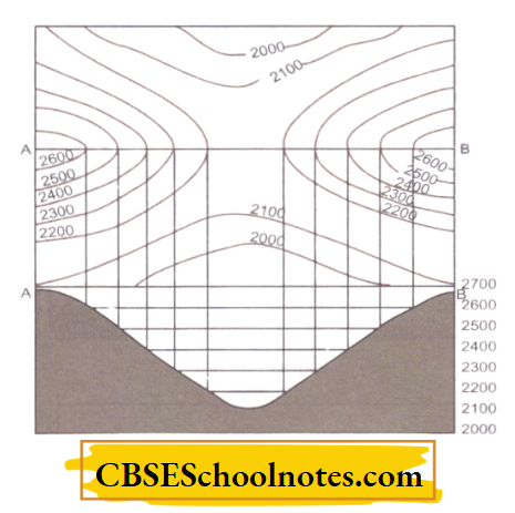
6. Col, Gap, Saddle and Pass:
A col is also sometimes called a saddle or a pass. It is a low point between two hills or between two peaks of a ridge.
- If the gap is wide it is known as a saddle.
- A pass is a lowland between two mountain peaks and provides a passage. The height of a pass is lower than the height of a saddle.
- A gap is a low lying depression or a valley which cuts through a range of hills. A river flows through a gap
- A saddle is so called because it resembles the shape ofa saddle used on horses. It does not provide passage through a mountain.
- The contour pattern showing a col or saddle also resemblesan hourglass or a sand clock.
Col:
Gap:

Saddle:

Pass:

CBSE Class 8 Geography Chapter 1 Settlements
Settlements are places where people build their houses and settle down more or less permanently. In other words, a settlement is a group of human dwellings in urban or rural areas. The place where a settlement develops is called a site.
Early human beings were hunters and gatherers.
- They used to move from one place to another in search of food and shelter.
- They lived in caves or on trees. Gradually, they learnt to grow crops.
- This made it necessary for them to have a permanent home. So they built permanent shelters in the form of huts and thus grew settlements near river valleys.
- The rivers provided them with water and fertile land to grow crops and a mode of transport using rafts and boats.
- Agriculture gave them surplus food and ample time to practice other crafts.
- Gradually, this led to the development of trade, commerce and manufacturing.
- For this, they built different types of structures like granaries, workshops, schools, temples, ports and so on.
- Consequently, human settlements became larger and gave way to villages and towns and finally to cities.
- This led to the growth ofa number of river valley civilisations like the Indus Valley Civilisation.
Settlements usually develop in areas which have a moderate climate, arable, fertile land, availability of water, the potential for providing jobs in mining and industries and easy access to other areas through roads, rivers, and railways.
- Therefore, settlements generally develop on level land where the construction of buildings, roads and railways is easier.
- In highland areas, settlements develop on the floors of valleys.
- Further, settlements come up in areas where there are ample opportunities for earning a living like in the vicinity of cities, in industrial areas and in tourist spots.
Types of Settlements
Based on the length of time for which a settlement is occupied by the people, there are two types of settlements
1. Temporary Settlements:
Temporary Settlements are those settlements that are inhabited for a short time and then abandoned.
- The people living in deep forests, hot and cold deserts and mountains reside in these temporary settlements.
- They practice hunting, gathering and shifting cultivation and transhumance (the practice of moving livestock from one grazing ground to another in a seasonal cycle, typically to lowlands in winter and highlands in summer.)
For example:
People living in the hilly terrain in Badrinath and Kedarnath in Uttarakhand stay there during the summer season and come down to the plains during the harsh winters.
- Some people never build a permanent settlement and are always on the move, like Gadia Lohars, a nomadic community of ironsmiths from Rajasthan.
- They move from one place to another on bullock carts, called gadi, hence their name, Gadia Lohars.
- The bullock carts are their homes. Temporary settlements are shown on a topographic sheet using squares with a red outline.

2. Permanent Settlements:
Permanent Settlements are those that are occupied for a very long period.
- These settlements can be either big or small.
- They include buildings for houses, schools, hospitals, offices, markets, cultural and entertainment centres, etc.
- Permanent settlements are shown on a topo-sheet using solid red squares.
Based on their size, population density, economic activities, development and the number and quality of public utility services,

Settlements can be classified into the following types:
Rural Settlements:
Rural Settlements are most closely and directly related to land and include villages.
- The design and use of building materials of houses vary from one region to another based on terrain, availability of raw material, season and monetary capability.
- Most of the houses in rural areas are made up of mud, wood and thatch.
- The main economic activities followed by the people in rural areas include agriculture, animal husbandry, fishing and forestry.
- The basic amenities, such as clean drinking water, electricity, schools and colleges, roads, and a communication network, are not as developed as in urban areas.
- In many developing countries of the world, rural areas lack basic facilities like toilets and proper garbage disposal, causing health related problems.
Urban Settlements include:
Urban Settlements: cities and towns. They are larger than rural settlements.
- Most of the people in urban settlements are engaged in non-agricultural activities such as manufacturing, trading and services.
- These areas have advanced amenities, better opportunities for education, health-care, employment, transportation, communication and overall better standard of living than rural settlements.
- Some of the cities and towns have gained prominence as specialised centres based on residential, recreational, transport, manufacturing, mining and information technology-related activities.
For example:
Bengaluru has emerged as the Information Technology hub in India.

Settlement Patterns
The Settlement Pattern refers to the arrangement of houses and other buildings in an area. In simple words, it means the shape of the settlements as seen from above.
Thus, based on the shape or pattern, the settlements can be classified into the following types:
1. Nucleated or Compact Settlements:
- These settlements are those in which a large number of houses are built very close to each other. Such settlements usually develop along river valleys and in fertile plains.
- These settlements often cluster around a central feature like a place of worship, an important building, a police station, a trade route and so on.
- In these settlements, communities are closely knit and share common occupations.
2. Dispersed or Scattered Settlements:
These settlements are those in which the buildings are scattered over a large area.
- They are mostly found in hilly tracts, thick forests and regions of extreme climate.
- This pattern is also associated with large farms and sparse population.
3. Linear Settlements:
These settlements are those in which the buildings are located in a line along a road, railway line, river, canal or the edge of a valley. Such settlements are also known as Ribbon-patterned Settlements.

CBSE Class 8 Geography Chapter 1 Interpretation And Analysis Of A Topo-Sheet
Interpretation of a Topo-sheet involves describing the physical and cultural features as shown on it as well as the interrelation between various features. For example, one can identify different physical features like relief, drainage and vegetation and then interpret how these physical features affect the cultural or man-made features.
Locating Features on a Topo-Sheet
For interpreting a topo-sheet, it is essential to first find out the location of a place on it. On an ordinary map prepared on a small scale, one can easily find out the location of a place with the help of a grid.
A grid is a set of lines that look like a ‘cell’ on a graph paper.
- Any feature on the map can be easily located by finding the cell in which it lies. In such maps, a grid is formed by the lines of latitude and longitude.
- Topographic maps, however, have a large scale and cover much smaller areas. Therefore, in these maps there is not enough space to form a grid of lines of latitude and longitude.
- To overcome this difficulty, a grid reference system formed by vertical and horizontal lines is used.
- These lines are drawn in red colour and each line is known by a two-digit number.
- These lines are drawn from the southwest corner of a topo sheet as the starting point.
- The vertical lines drawn east of this point are called Eastings, and the horizontal lines drawn north of this point are called Northings.
The Eastings increase in value eastwards, whereas the Northings increase in value northwards.

In the figure given above, the lines numbered 32, 33, 34 and 35 are Eastings, and the lines numbered 11, 12, 13, and 14 are Northings.
- These Northings and the Eastings cut across each other to form squares or grids.
- These lines are the basis for reference to landmarks and places shown on the map.
- To find out the location that lies within a particular square, a grid reference system is used.
- In this type of reference, the first two figures give the Eastings, whereas the last two give the Northings.
- For example, the temple in the above figure has the four-figure grid reference 3211.
- This means that the temple is located in the 1 km square with Eastings for 32 and Northings of 11.
- Thus, large lakes, meanders, streams, settlements, embankments, physical features, etc., which occupy some space on the map, can be located by using a four-figure reference.
- With the help of contour map information and use of conventional signs and symbols,

A topographic sheet is usually interpreted under the following heads:
1. Marginal Information:
It includes the topographical sheet number, like G43S7 and G43S10, its location, grid references, its extent in degrees and minutes, scale, contour interval, legend, the districts covered, etc. It gives an idea as to which part of country is being depicted by the map

2. Relief of the Area:
The general topography or the relief of the area is studied under the following heads:
- Hill: With concave, convex, steep or gentle slope and shape.
- Plateau: Whether it is broad, narrow, flat, undulating or dissected.
- Plain: Its types, i.e., alluvial, glacial, coastal, marshy, etc.
- Mountain: Its general elevation, peak, passes, area, etc.
3. Drainage of the Area:
The important rivers and their tributaries and the type and extent of valleys formed by them.
4. Land Use:
It includes the use of land under different categories, like
- Natural vegetation and forest
- Agricultural, orchard, wasteland, industrial area, etc
- Facilities and services such as schools, colleges, hospitals, parks, airports, electric substations, etc.
5. Transport and Communication:
The means of transportation include national or state highways, district roads, cart tracks, camel tracks, footpaths, railways, waterways, majorcommunication lines, post offices, etc.
6. Settlements:
These are studied under thefollowing heads:
- Rural Settlements
- Urban Settlements ; and
- The pattern of settlements.
7. Occupation:
The general occupation of the people of the area may be identified with the help of land use and the type of settlements.
For example:
In rural areas, the main occupation of the people is agriculture; in coastal areas, fishing is practised. Similarly, in cities and towns, services and businesses appear to be the major occupations of the people.