
CBSE Notes For Class 6 Geography Social Science Chapter 2 Globe Latitudes And Longitudes
Globe
- The globe is a true model of the Earth (in small form). The size of the globe varies from small to big. The countries, continents, and oceans are shown in their correct sizes on the globe.
- The needle fixed through the globe in a tilted manner is called its axis. However, the real Earth does not have such a needle. The Earth moves around its axis, which is an imaginary line.
- The two points on the globe where the needle passes are the North Pole and the South Pole. The globe can be moved around this needle from West to East just like the Earth.
Equator: It is another imaginary circular line that runs through the globe and divides the Earth into two equal parts.
These are
- Northern Hemisphere The Northern half of the Earth is known as Northern Hemisphere.
- Southern Hemisphere The Southern half of the Earth is known as Southern Hemisphere.
Therefore, the equator is an important reference point for locating places on the Earth.
CBSE Notes For Class 6 Geography Chapter 2 Latitudes
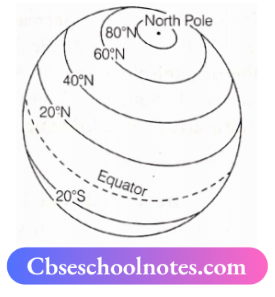
- An imaginary circle parallel to the equator is called latitude. All parallel circles from the equator up to the poles are called parallels of latitudes. These are measured in degrees.
- All parallel circles North of the equator are called North latitudes while all parallels South of the equator are called
- South latitudes. The North and South latitudes are indicated by the letters ‘N’ and ‘S’ respectively.
- The equator represents the zero-degree latitude. The distance from the equator to either of the poles is one-fourth of a circle around the Earth (1 /4th of 360 degrees, i.e. 90°).
- Hence, 90 degrees North latitude marks the North Pole and 90 degrees South latitude marks the South Pole.
Difference between North and South Latitude
- The difference between North and South Latitude can be understood through the example of Chandrapur in Maharashtra (India) and Belo Horizonte in Brazil (South America).
- Both of these places are located on parallels of about 20° latitude. However, the difference between both locations is their position in North and South latitudes respectively.
- Chandrapur in Maharashtra (India) is situated at 20° North of the equator while Belo in Brazil is situated at 20° South of the equator. Thus, Chandrapur is at 20° N latitude and Belo Horizonte at 20° S latitude.
- As one moves away from the equator, the size of the parallels of latitude decreases.
Important Parallels of Latitudes: Besides the equator (0°), the North Pole (90°N), and the South Pole (90° S), there are four important parallels of latitudes. These are
- Tropic of Cancer (231/2° N) in the Northern Hemisphere.
- Tropic of Capricorn (23fc° S) in the Southern Hemisphere.
- Arctic Circle at 66V2° North of the equator.
- Antarctic Circle at 66V20 South of the equator.
CBSE Notes For Class 6 Geography Chapter 2 Heat Zones of the Earth
- Torrid Zone: For at least once a year, the mid-day Sun is exactly overhead on all latitudes between the Tropic of Cancer and the Tropic of Capricorn.
- As a result of this, the area between the Tropic of Cancer and the Tropic of Capricorn receives the maximum heat, and this area is called the Torrid zone.
- The mid-day Sun never shines overhead on any latitude beyond the Tropic of Cancer and Tropic of Capricorn.
Temperate Zones
The angle of the ray of the Sun goes on decreasing towards the poles. Thus, the areas between the Arctic Circle and Tropic of Cancer in the Northern Hemisphere and the Antarctic Circle and Tropic of Capricorn in the Southern Hemisphere have moderate temperatures. These areas are called temperate zones.
CBSE Notes For Class 6 Geography Chapter 2 Longitudes
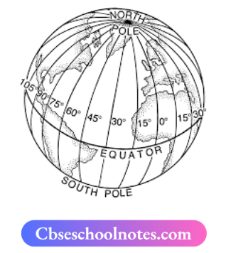
- An imaginary circle parallel to the Prime Meridian i. called longitude.
- It is difficult to locate a place exactly if two or more places are situated on the same latitude.
- For example, the Tonga Islands in the Pacific and the Mauritius Islands in the Indian Ocean are situated at the same latitude (20° S).
- Thus, in order to locate these places exactly, it is necessary to know how far East or West are these places from the line of reference running from the North Pole to the South Pole. These lines of reference are called meridians of longitude.
- The distance between the meridians is measured in degrees. Each degree is divided into minutes and minutes are further divided into seconds.
- The distances between meridians decrease polewards and become zero at the poles. All the meridians meet at zero degrees. All meridians are of equal length, unlike parallels of latitude.
- The counting of longitude starts from the meridian which passes through Greenwich where the British Royal Observatory is located. This meridian is called the Prime Meridian.
- It has a value of 0° longitude, with counting extending 180° Eastward and 180° Westward.
- The Prime Meridian and 180° meridian divides the Earth into two equal halves, the Eastern Hemisphere and the Western Hemisphere, denoted by letters ‘E’ and ‘W’ respectively. The 180° East and 180° West meridians are on the same line.
Longitude and Time: The best method of measuring time is by the movement of the Earth, the Moon, and the planets.
- Local time is determined by the shadow formed by the Sun which is shortest at noon and longest at sunrise and sunset.
- When the Sun is at its highest point along the Prime Meridian at Greenwich, all places on this meridian experience mid-day or noon.
- As the Earth rotates from West to East, the places located to the East of Greenwich are ahead of Greenwich time, while places located to the West are behind the Greenwich time.
- Earth completes a 360° rotation in 24 hours, which means 15° per hour or 1° in four minutes.
- When it is 12 noon at Greenwich, the time at 15° east of Greenwich will be 15 x 4 = 60 minutes, i.e. 1 hour ahead of Greenwich time, which means 1 p.m.
- However, at 15° West of Greenwich, the time will be behind Greenwich time by one hour, i.e. it will be 11.00 a.m.
Knowledge Plus: The Earth has been divided into twenty-four time zones of one hour each. Each zone thus covers 15° of longitude.
Standard Time: It is necessary to adopt the local time of some central meridian of a country as the standard time for the country. It is because there is a difference in the local times on different meridians.
- In India, the longitude of 821/2° E (82° 30’E) is considered as the standard meridian, and the local time at this meridian is taken as the standard time for the whole country. It is known as the Indian Standard Time (1ST).
- India is located East of Greenwich at 82°30’E, thus it is 5 hours and 30 minutes ahead of GMT.
- Some countries have adopted more than one standard time as they have a great longitudinal extent. For example, in Russia, there are eleven standard times.