
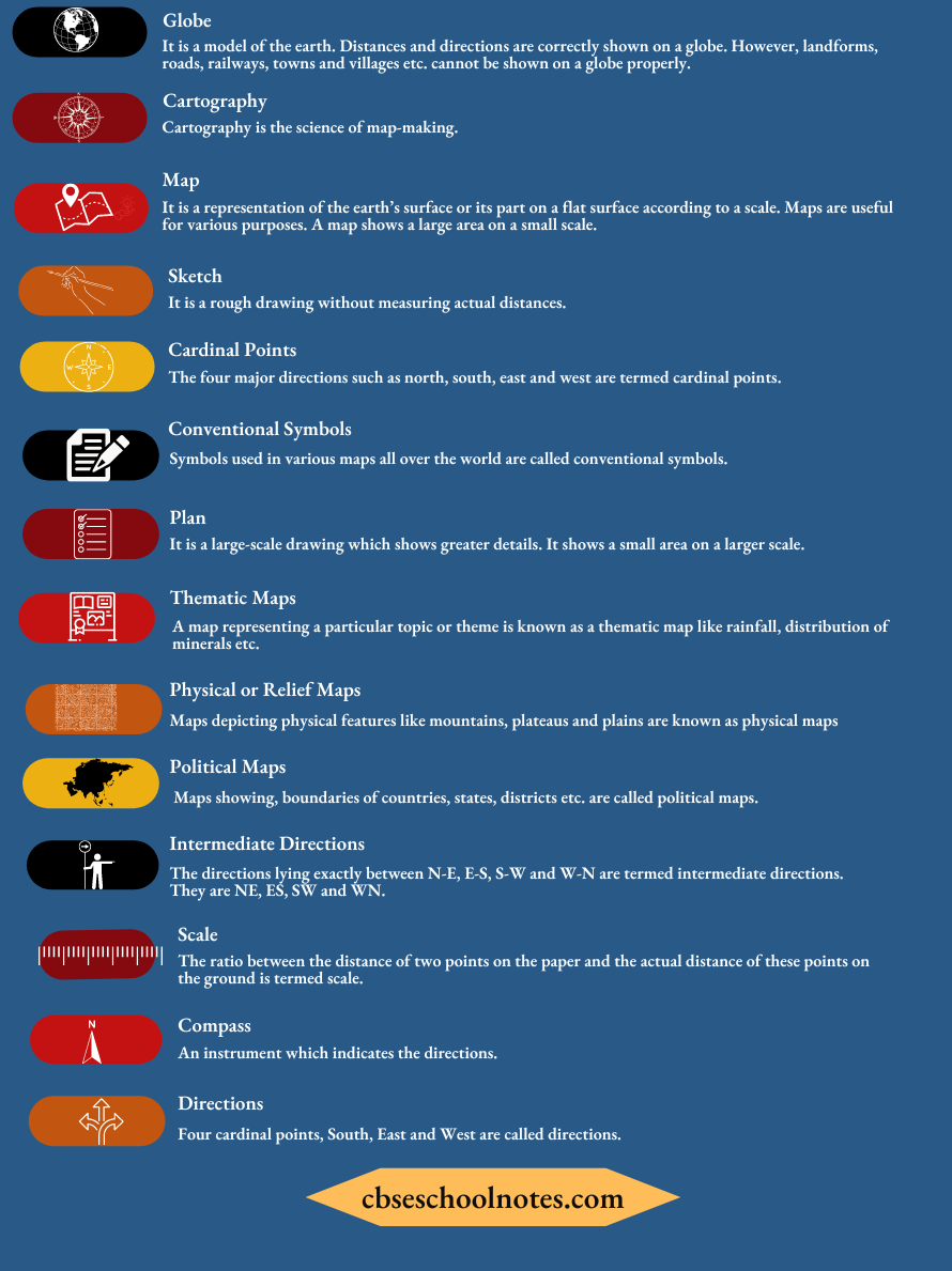
Maps
Maps Facts To Remember
- Three components of maps are — distance, direction and symbols.
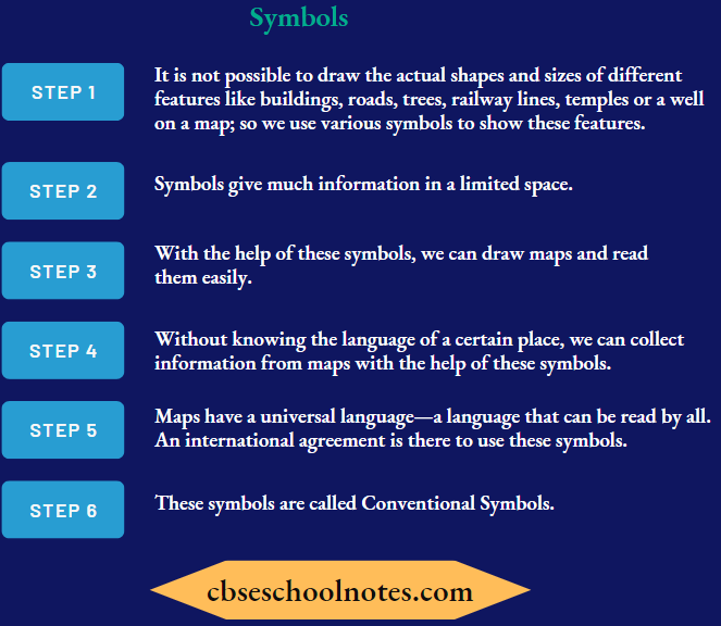
- Symbols are used to show features like roads, bridges, railways etc.
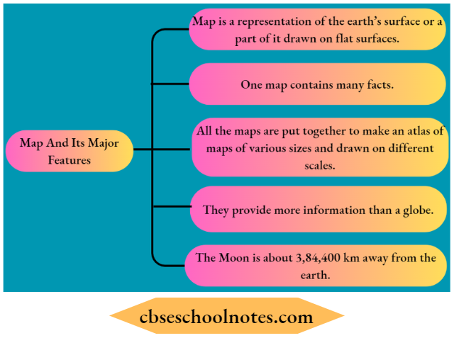
- Maps provide more information than a globe.
Maps Keywords
Read and Learn More CBSE Solutions For Class 6 Social Science
Maps Exercises
Question 1. Answer the following questions briefly.
- What are the three components of a map?
- What are the four cardinal directions?
- What do you mean by the term ‘the scale of the map’?
- How are maps more helpful than a globe?
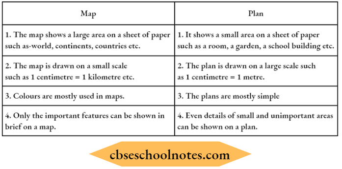
- Distinguish between a map and a plan.
- Which map provides detailed information?
- How do symbols help in reading maps?
Answer:
(1) Three components of a map.
- Distance
- Direction
- Symbols
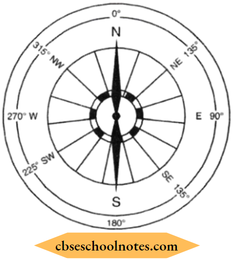
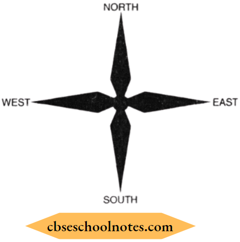
(2) Four cardinal directions:
- North
- South
- East
- West
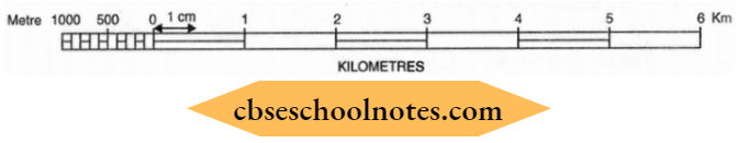
(3). The Scale of the Map:
The ratio between the distance on the paper and the actual distance on the ground is defined as the scale of the map.
Example: 1 cm = 5 kms.
- It means the distance on the paper between two points is 1 cm.
- The distance on the ground (actual distance) is 5 km.
- 1 cm distance on the paper represents a 5 km distance on the ground.
(4). Maps are more helpful than globe because of the following reasons:
- Globe cannot be used in all conditions.
- Globe can be used only when we want to study the whole Earth.
- It cannot be used when we want to study a village, road, building etc.
- Maps are used in the study of features more minutely.
- It contains innumerable facts.
- Maps can be found in the form of an Atlas.
- Maps provide more information than the Globe.
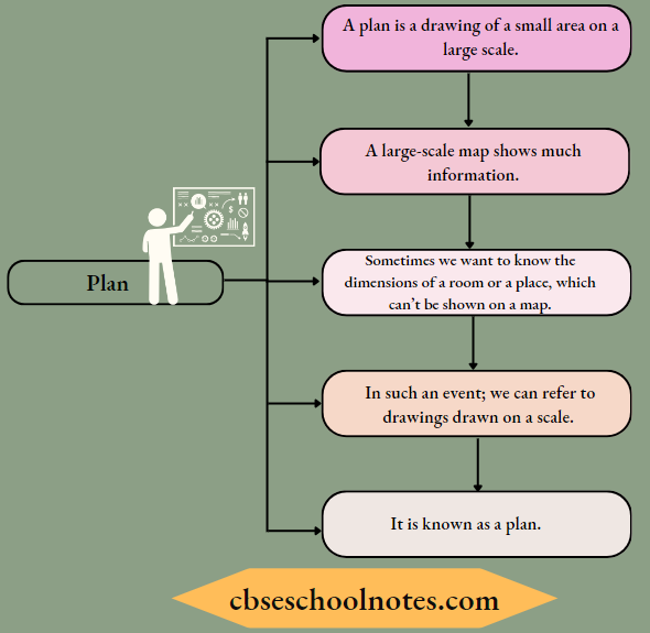
(5). Distinction between a map and a plan.
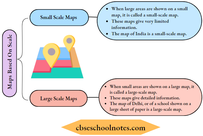
(6). Large-scale maps provide detailed information. They show small areas on a large scale.
(7) With the use of symbols maps are more informative and easier to read because of the following reasons:
- By symbols, we can easily recognise the places such as: -rivers, temples, mosques, trees, etc.
- Language does not put any problem in understanding the feature.
- Even the less educated can understand the information easily.
Question 2. Match the correct answer:
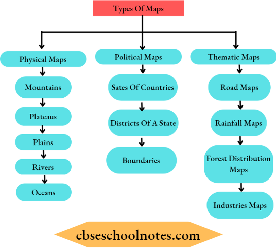
(1) Maps showing the distribution of forests are:
- Physical map
- Thematic map
- Political map
Answer: 2. Thematic map
(2) The blue colour is used for showing:
- Water bodies
- Mountains
- Plains
Answer: 1. Water bodies
(3) A compass is used
- To show symbols
- To find the main direction
- To measure distance
Answer: 2. To find the main direction
(4) A scale is necessary
- For a map
- For a sketch
- For symbols.
Answer: 1. For a map
Map Very Short Type Questions And Answers
Question 1. What are the limitations of a globe?
Answer:
- Globe is of little help when we want to study only a part of the earth, about our country, states; districts, towns and villages.
- Globe is not easy to handle.
Question 2. What is an atlas?
Answer:
A collection of maps is an atlas.
Question 3. What is a north line?
Answer:
An arrow marked with the letter N at the upper right-hand comer of a map is called the north line.
Question 4. Which instrument helps to find direction?
Answer:
The instrument is called a compass.
Maps Short Type Questions And Answers
Question 1. What is a map? Describe its major features.
Answer:
Question 2. How are different physical features shown on the map?
Answer:
Symbols and colours are used to show physical features.
For example, brown colour for mountains, blue colour for water bodies, green colour for forests.
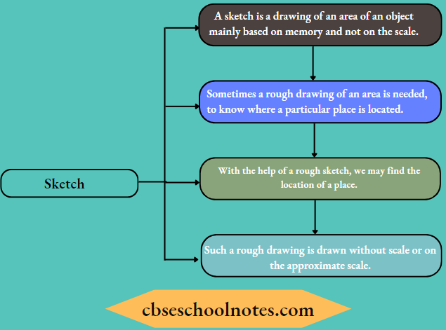
Question 3. Define Sketch.
Answer:
Question 4. What is a Plan?
Answer:
Question 5. Describe various types of maps.
Answer:
Maps are of various types. They are:
Question 6. Explain the two types of maps based on scale.
Answer:
Question 7. How are directions known?
Answer:
Directions are known by the following ways:
- Maps contain an arrow marked with the letter ‘N’ on the upper right side.
- This arrow shows the North direction.
- It is called the north line, with this one can find out other directions For Example. north, east, west and south are called cardinal points.
- The other four intermediate directions are North-East (NE), South-East (SE), South-West (SW) and North-West (NW).
- One can locate any place more accurately with the help of these intermediate directions.
- One can also know the directions with the help of a compass.
Maps Long Type Questions And Answers
Question 1. How is the distance measured? Define a scale.
Answer:
- Maps reduce the entire world or its parts to fit on a sheet of paper.
- But this reduction is done very carefully so that the distance between the places Eire kept true.
- By reduction of the map, a small distance on paper represents a large distance on the ground.
- To reduce a map, a scale is chosen.
- Scale is the ratio between the actual distance on the ground and the distance shown on the map.
- The distance between the school and home of the student is 10 km. If he shows this 10 km distance by 2 cm on the map, it means, 1 cm on the map will show 5 km on the ground. Thus the scale will be 1 cm = 5 km.
- Scales are used for measuring distances.
For example, to find out the distance between the post office and the clock tower, one can measure the distance between these points on the map and calculate the actual distance as per the scale.
Question 2. What are symbols? Why do we need them?
Answer:
Maps Multiple Choice Questions And Answers
Question 1. What is a map?
- A globe
- A drawing of the earth’s surface on a flat paper according to scale
- A projection
- None of these
Answer: 2. A drawing of the earth’s surface on a flat paper according to scale
Question 2. What is a physical map?
- Showing natural features of the earth such as mountains, rivers etc.
- Showing cities, towns and villages with boundaries
- Showing rainfall, distribution of forests etc.
- None of the above
Answer: 1. Showing natural features of the earth such as mountains, rivers etc.
Question 3. Which map gives more information?
- Small scale map
- Large scale map
- Ordinary map
- None of the above
Answer: 2. Large-scale map
Question 4. What does ‘N’ with the arrow show?
- Direction of North
- Direction of East
- Direction of West
- Direction of South
Answer: 1. Direction of North
Question 5. The blue colour is used for showing
- Mountains
- Plants and trees
- Water
- None of the above
Answer: 3. Water
Question 6. A scale is compulsory for
- A map
- A sketch
- A symbol
- All of these
Answer: 1. A map
Question 7. For what purpose magnetic compass is used?
- For measuring distance
- For showing symbols
- To find the directions
- For all of these
Answer: 3. For finding the directions
Question 8. The plan is a drawing of
- A small area on a large scale
- Large area on a small scale
- Both (1) and (2)
- None of these
Answer: 1. Small area on a large scale
Question 9. Yellow colour is used for showing
- Plateau
- Water bodies
- Mountains
- Plants
Answer: 1. Plateau
Maps Objective Type Questions And Answers
Question 1. Fill in the blanks with appropriate words:
(1). We need a _________ to study earth as a whole.
Answer: Globe
(2). There are _________ intermediate directions.
Answer: Four
(3). __________ colour is used to show plateaus.
Answer: Yellow
(4). ________ is used to show post and telegraph office on the map.
Answer: P.T.O
Question 2. Match the contents of Column A with that of Column B.
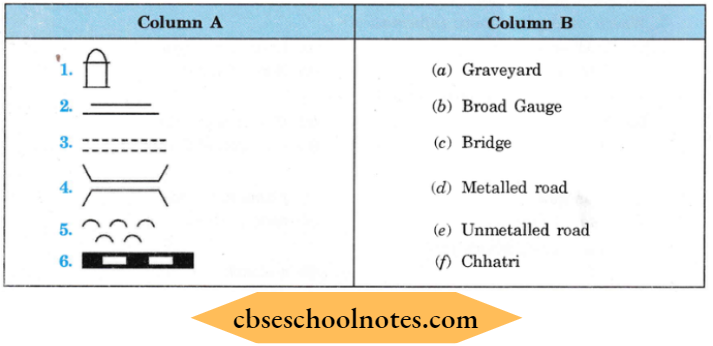
Answer: 1-(f), 2-(d), 3-(e), 4-(c), 5-(a), 6-(b)
Question 3. State whether the given statements are true or false.
(1). A scale is not compulsory for a map.
Answer: False
(2). Small-scale maps are used to show continents and oceans.
Answer: True
(3). Plan does not require a scale.
Answer: False
(4). Green colour on maps indicates hills.
Answer: False