
Our Country India Exercises
Question 1. Answer the following questions briefly:
- Name the major physical divisions of India.
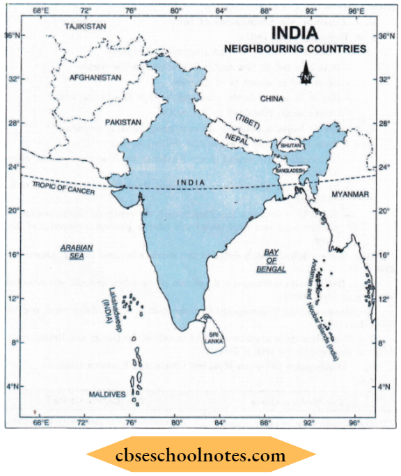
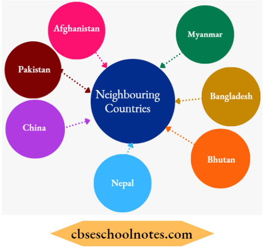
- India shares its land boundaries with seven countries. Name them.
- Which two major rivers fall into the Arabian Sea?
- Name the delta formed by the Ganga and the Brahmaputra.
- How many States and Union Territories are there in India? Which states have a common capital?
- Why do a large number of people live in the Northern plains?
- Why is Lakshadweep known as a coral island?
Answer:
(1). Major physical divisions of India:
- The Himalayas
- The Northern Indian Plains
- The Peninsular Plateau
- Great Indian Desert
- The Coastal Plains
- The Islands
(2). Countries sharing land boundaries with India:
- Pakistan
- Afghanistan
- China
- Nepal
- Bhutan
- Myanmar
- Bangladesh
(3). (1). Narmada, (2) Tapi (Tapti)
Read and Learn More CBSE Solutions For Class 6 Social Science
(4). Delta formed by Ganga and Brahmaputra: Sunderban.
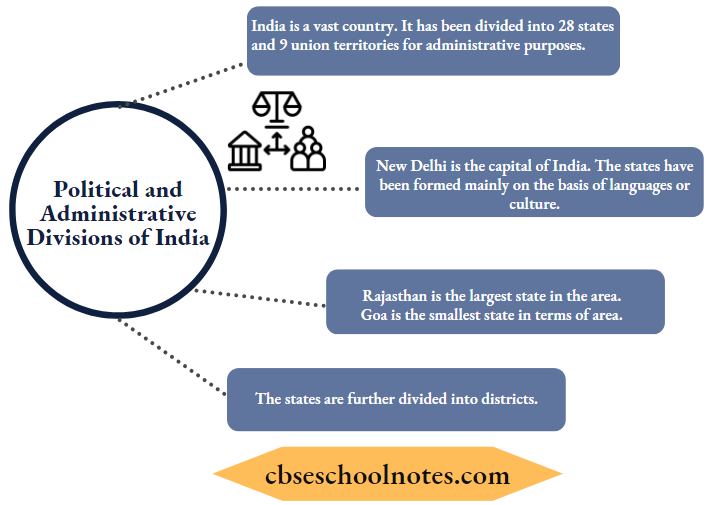
(5). States: 29, Union Territories: 07.
The States of Punjab, Haryana and the Union Territory of Chandigarh have a common capital at Chandigarh.
Hyderabad was a common capital of Telangana and Andhra Pradesh.
(6) Large number of people live in the northern plains because of the following reasons:
- Fertile land provides facilities for agriculture.
- Means of transport and communication can be developed easily.
- More employment opportunities exist in the plains.
- Water is easily available.
- Industries provide employment (Agro-based and other industries)
(7). Lakshadweep is a coral island because of the following reasons:
- Climate and seawater suitable for the growth of polyps.
- Their skeletons pile up and form islands.
Question 2. Match the correct answers.
(1). The Southernmost Himalayas are known as
- Shiwaliks
- Himadri
- Himachal
Answer: 1. Shiwaliks
(2). Sahyadris are also known as
- Aravali
- Western Ghats
- Himadri
Answer: 2. Western Ghats
(3). The Talk Strait lies between the countries
- Sri Lanka and Maldives
- India and Sri Lanka
- India and Maldives
Answer: 2. India and Sri Lanka
(4). The Indian islands in the Arabian Sea are known as
- Andaman and Nicobar Islands
- Lakshadweep Islands
- Maldives
Answer: 2. Lakshadweep Islands
(5) The oldest mountain range in India is the
- Aravali hills
- Western ghats
- Himalayas
Answer: 1. Aravali hills
Question 3. Fill in the blanks:
(1). India has an area of about __________.
Answer: 3.28 million sq. kms.
(2). The Greater Himalayas are also known as _________.
Answer: Himadri
(3). The river Narmada falls into the ___________ sea.
Answer: Arabian
(4). The latitude that runs almost halfway through India is _________.
Answer: Tropic of Cancer
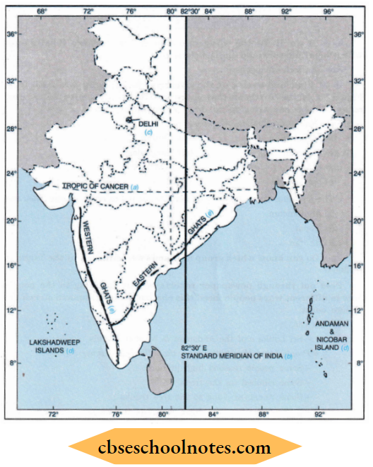
Question 4. On an outline map of India, mark the following:
- Tropic of Cancer
- Standard Meridian of India
- The state in which you live
- The Andaman Islands and Lakshadweep Islands
- Western Ghats and Eastern Ghats.
Answer:

Question 5. If we divide the world into Eastern and Western Hemispheres which hemisphere would India belong to?
Answer:
Eastern Hemisphere.
Question 6. Find out the names of the countries (neighbouring countries) that share land boundaries with India. How many of these countries do not have access to any ocean or sea?
Answer:
Seven neighbouring countries are:
The following three countries do not have access to the ocean or sea: They are:
- Afghanistan
- Nepal
- Bhutan
Question 7. Do you know which group of islands were affected by the Tsunami in 2004? Find out through newspaper reports and by speaking to the people how in different ways people faced this challenge when the Tsunami struck the Indian coast.
Answer:
- Yes,
- Sri Lanka and the Andaman & Nicobar Islands.
- People faced the challenge in the following manner:
- Some people reached high grounds.
- Some climbed up the trees.
- Some remained clung to the tree trunks.
- Some climbed up the upper storey of the house.
- Some swam in the rising waves.
- Hundreds of thousands perished in the waves.
Our Country India Very Short Type Questions And Answers
Question 1. Define polyps. How are coral islands formed?
Answer:
- Corals are the collection of skeletons of tiny marine animals. They are called polyps.
- When the living polyps die their skeletons are left. Other polyps grow on top of the hardened skeleton, which grows higher and higher in the course of time.
- Thus coral islands are formed.
Question 2. How much is the time difference from one latitude to another?
Answer:
The time changes by four minutes for every one degree of longitude.
Question 3. What is the basis of state formation?
Answer:
The states were formed, generally, based on language or culture.
Question 4. What is the word “Himalayas” signifies?
Answer:
The word Him + alaya signifies ‘the abode of snow’.
Question 5. Define a Peninsula.
Answer:
It is a piece of land which is surrounded by water on its three sides.
Question 6. What is a desert?
Answer:
Vast area covered with sand.
Question 7 What is the mouth of a river?
Answer:
The area where a river meets the sea or ocean is called as mouth of the river.
Our Country India Short Type Questions And Answers
Question 1. Describe the boundaries of India.
Answer:
Boundaries of India.
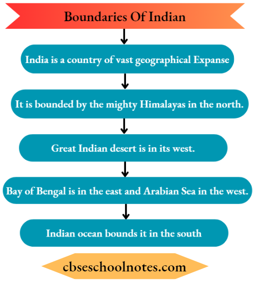
Question 2. How is India a country of vast geographical expanse?
Answer:
India has an area of about 3.28 million sq. km.
- Its north-south extent from Kashmir to Kanyakumari is about 3,200 km.
- Its east-west extent from Arunachal Pradesh to Kuchchh is about 2,900 km.
- The lofty mountains, the Thar desert, the northern plains, the peninsular plateau, the east and west coasts and the islands present a diversity of landforms.
Question 3. Define delta. Which delta is the world’s largest delta? Where is it situated?
Answer:
Delta. Delta is the triangular deposition of the debris brought and deposited by rivers at their mouth.
The Ganga and the Brahmaputra form the world’s largest delta which is called the Sunderban Delta.
The Sunderban Delta is situated at the mouth of the Ganga and Brahmaputra rivers at the head of the Bay of Bengal.
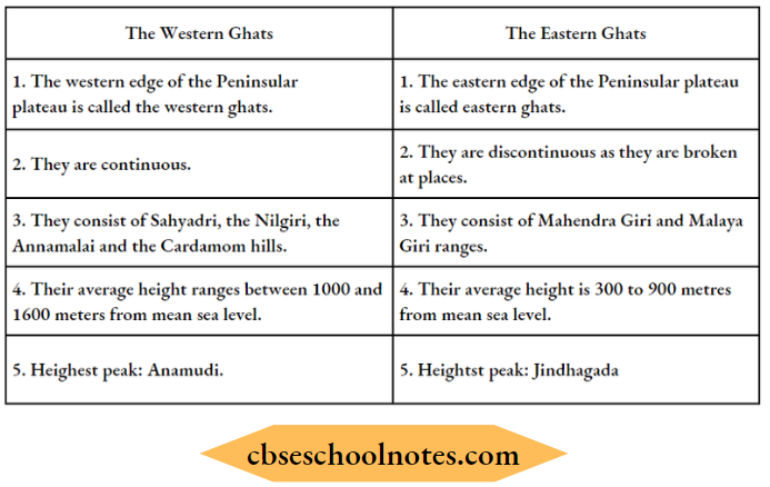
Question 4. Distinguish between Western Ghats and Eastern Ghats.
Answer:
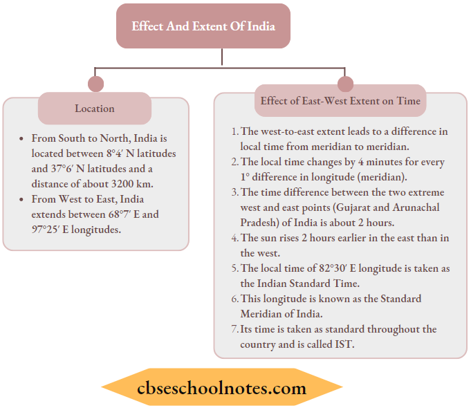
Question 5. What is the locational extent of India? State the effect of East-West extent of India on time.
Answer:
Question 6. Briefly write about the Great Indian Desert.
Answer:
Great Indian Desert or Thar Desert lies to the west of India. It is a hot dry and sandy piece of land.
It has very little vegetation like cactus, kikar, babul etc. It has a very small population.
Our Country India Long Type Questions And Answers
Question 1. Describe the Himalayas.
Answer:
The Himalayas
- The Himalayas are in the north of India.
- They are the lofty snow-capped mountains.
- Him + alaya means ‘the Abode of Snow’.
- The Himalayan mountains are divided into three main parallel ranges.
- The northernmost is the Great Himalayas or Himadri. The world’s highest peaks like Mt. Everest and Kanchenjunga are located in this range.
- Middle Himalayas or Himachal lies to the South of Himadri.
- Numerous popular hill stations are situated here. Gulmarg Dharmashala, Kullu, Manali, Kausani etc. are important hill stations.
- The Shiwaliks are in the southernmost range of the Himalayas. It has several longitudinal valleys called ‘duns’. Dehradun is an example of dun.
- Shimla, Kasauli, Nainital etc. are hill stations in this range.
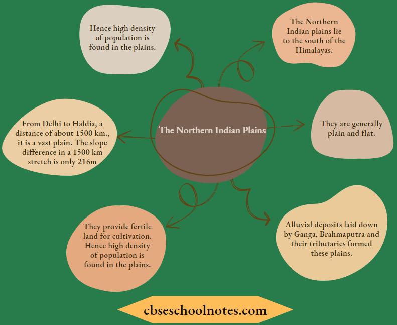
Question 2. Give an account of the Northern Indian Plains.
Answer:
Question 3. Explain the major features of the Peninsular Plateau.
Answer:
Peninsular Plateau
- South of the northern plains lies the Peninsular plateau.
- It is triangle-shaped.
- Its relief is highly uneven.
- It has numerous hill ranges and valleys.
- Aravali Hills are one of the oldest ranges in the world. They border the plateau on the northwest side.
- The Vindhyas and the Satpuras are the other important ranges.
- Major towns in the Deccan plateaus are:
- Indore, Ujjain, Bengaluru, Vijaynagar, Hyderabad etc.
- Narmada and Tapi flow through these ranges. They are west-flowing rivers. They drain water into the Arabian Sea.
- Mahanadi, Godavari, Krishna and Kaveri are major east-flowing rivers. They drain into the Bay of Bengal.
- The Western Ghats or Sahyadris border the plateau in the west. The Eastern Ghats form its eastern boundary.
- The plateau is rich in minerals. Coal and iron ore are the important minerals found on this plateau.
Question 4. Describe the Coastal Plains and the Island groups.
Answer:

Question 5. With the help of a map of India describe the political and administrative divisions of India.
Answer:
Our Country India Multiple Choice Questions And Answers
Choose the correct answer:
Question 1. India is located in the:
- Western hemisphere
- Eastern hemisphere
- Both (1) and (2)
- None of these
Answer: 2. Eastern hemisphere
Question 2. Which country shares land boundaries with 7 countries?
- England
- Australia
- India
- South Africa
Answer: 3. India
Question 3. Where does the Great Indian Desert lie?
- In the eastern part of India
- In the western part of India
- In the northern part of India
- In the southern part of India
Answer: 2. In the western part of India
Question 4. What lies to the south of the northern plains of India?
- Great Indian desert
- Peninsular plateau
- Vindhyas
- Western Ghats
Answer: 2. Peninsular plateau
Question 5. Where do the rivers Mahanadi, Godavari, Krishna and Kaveri drain?
- Arabian Sea
- Indian Ocean
- Bay of Bengal
- None of these
Answer: 3. Bay of Bengal
Question 6. The Indian islands in the Bay of Bengal are known as:
- Andaman and Nicobar Islands
- Maldives
- Lakshadweep
- None of these
Answer: 1. Andaman and Nicobar Islands
Question 7. Which hills are located in Rajasthan?
- Aravali hills
- Western Ghats
- Himalayas
- All of these
Answer: 1. Aravali hills
Question 8. The number of states in India divided for administrative purposes are
- 21
- 23
- 25
- 28
Answer: 4. 28
Question 9. How many Union Territories are there in India?
- 4
- 6
- 7
- 8
Answer: 3. 7
Question 10. Which is the National Capital of India?
- Mumbai
- Kolkata
- Chennai
- New Delhi
Answer: 4. New Delhi